Tools to Start a Program
This page provides resources for educators seeking to begin a new geospatial program or expand and sustain an existing program. While every college and its service region have unique needs, many of the steps and resources necessary to start and nurture a successful program are similar. We have collected the essential recommendations and resources here on this one page to guide you through the process.
Geospatial curriculum results from a time-proven methodology of analyzing your local workforce needs and designing an academic program to educate the workforce for skills needed in your local area. On this page, we provide you a step-by-step guide to assess your own needs and design an exemplary program around those needs.
Developing a Geospatial Program
Use this whitepaper to help guide you through the process of creating and improving a two year college geospatial technology program. The whitepaper includes step by step logic model flowchart and recommendations. Written by former Esri Higher Education manager, Ann Johnson, for the GeoTech Center.
Model Certificate and Course Descriptions
The GeoTech Center, a National Science Foundation (DUE 1304591) grant to support geospatial programs at two-year colleges, developed Model Courses focused on building the skills, competencies, and abilities needed for entry-level occupations in the geospatial industry. Competencies covered in the Model Courses were identified using the Geospatial Technology Competency Model (GTCM) and outcomes from multiple DACUM (“Developing a Curriculum”) events. A panel of geospatial education experts parsed the competencies into the Model Courses for the Certificate. All material is distributed freely under a Creative Commons license and can be used with attribution to GeoTech. To track the use of the resources, we require you to login to view the full content for each Model Course, but you can see the Syllabus and short Description for each course.
Meta-DACUM Job/Occupation Analysis for GIS and Remote Sensing
GTCM Model Program Content Tool (with Rankings)
This worksheet is designed to help educators participating in the GTCM Course Workshops identify what skills and competencies should be included in a curriculum for entry level geospatial programs (Technician/Technologist) based on the Meta-DACUM outcome and the Department of Labor's Geospatial Technology Competency Model (GTCM). This spreadsheet contains the RESULTS of previous GTCM workshops and represents a CONSENUS value that each competency should be covered in similar courses. Matrix rows list key competencies and critical work functions identified by the Meta-DACUM expressed in a modified Bloom's taxonomy format. Columns represent the array of courses and other formal educational experiences included in a Model geospatial curriculum. Educators can enter the value (based on a scale of 0 to 4) representing whether that competency should be included or not included in a specific course. No course or program will address all competencies. Last updated June 10, 2014.
GTCM Program Assessment Tool
This worksheet is designed to help educators assess how their geospatial curricula align with workforce needs in the geospatial industry. The worksheet consists of a matrix corresponding to one of the five tiers of the Department of Labor's Geospatial Technology Competency Model (GTCM). Matrix rows list key competencies and critical work functions identified by workforce analysts and geospatial professionals. Columns represent the array of courses and other formal educational experiences included in a curriculum. Educators can enter into the matrix how and to what degree a particular course addresses each competency based on the Mastery Level Definitions listed on the Definitions tab of this worksheet. Entries selected from drop-down lists will be displayed graphically to provide a qualitative visual of course/program strengths, weaknesses and gaps. Quantitative measures are also calculated indicating overall alignment with the GTCM (percent of competencies addressed) at both the course and program level. No course or program will address all competencies.
The worksheet is not limited to assessment of academic curricula. It can also be utilized for other purposes such as self-assessment or employee assessment. Last updated: September 1, 2014.
Model Certificate and Course Descriptions with Tools for Program Development
Model Course and Certificate Development
Ann Johnson provides a narrative on the steps used to create the GTCM Model Courses and Certificate from the original GTCM to Faculty Development workshop
Model Course and Certificate Development Process Explained
Ann Johnson provides a narrative on the steps used to create the GTCM Model Courses and Certificate from the original GTCM to Faculty Development workshops.
Department of Labor GIS Technician Occupation Description
The Department of Labor provides occupation descriptions on their O-Net website. This link provides you the current DOL occupation description for GIS Technician. You will find John Johnson's article much more detailed in actual technician knowledge, skills, and tasks.
What GIS Technicians Do
A consolidation of 8 DACUM Job Analyses for GIS Technicians from across the United States published in the URISA Journal Volume 22, Issue 2, 2010. Includes supplemental tables. Identifies 55 common task categories, 35 knowledge and skill categories and 27 behavior categories which are itemized, ranked and documented. This information can serve as the basis for new job descriptions, curriculum resources for education and training, criteria for inter-institutional program articulation, and requirements for professional certification.
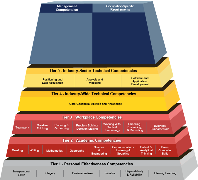
The Geospatial Technology Competency Model framework was developed through a collaborative effort, involving the Employment and Training Administration (ETA), the National GeoTech Center of Excellence, and industry experts.
Over the course of 2013-2014, the GeoTech Center and industry subject matter experts updated the model with guidance from ETA to reflect the knowledge and skills needed by today's geospatial technology professionals.
Over the course of 2013-2014, the GeoTech Center and industry subject matter experts updated the model with guidance from ETA to reflect the knowledge and skills needed by today's geospatial technology professionals.
Developing a Curriculum (DACUM) is a process that incorporates the use of a focus group in a facilitated story-boarding process to capture the major duties and related tasks included in an occupation, as well as, the necessary knowledge, skills, and traits. This cost-effect method provides a quick and thorough analysis of any job.
It is a means of researching and analyzing a particular job that results in a chart listing the duties, tasks, and related information about the job. That information can be applied in the development of a curriculum (and individual lesson plans) to assure and, in fact, document, that the content is directly relevant to what is required on the job.
While there can be some variations in the DACUM process, basically, a panel of incumbents in the job (usually those who perform it well), develop a list of all the duties and tasks assocaited with the job based on consensus of the panel. The panel also develops a list of knowledge and skills, tools, and equipment that are essential for success. This all becomes compiled in a DACUM chart, which is a road map for identifying relevant training topics. Since resources are limited and the DACUM chart can be quite extensive, the same panel or a panel of their superiors (sometimes called a validation panel) will set priorities in terms of how frequently a task is performed and how critical it is to the mission. This can reduce the training burden to more manageable levels in a legitimate manner via the expert panel analysis.
Meta-DACUM Job/Occupation Analysis for GIS & Remote Sensing
June, 2014
DACUM Research Chart for GIS Specialist, UT
March 27th & 28th, 2014
DACUM Research Chart for Geospatial Analyst, VA
October 22nd & 23rd, 2013
DACUM Research Chart for Remote Sensing Specialist, CO
September 14th & 15th, 2011
DACUM Research Chart for Remote Sensing Specialist, WI
May 1st & 2nd, 2011
DACUM Research Chart for Remote Sensing Specialist, CA
August 20th & 21, 2009
The National GeoTech Center plans to conduct two new DACUMs for task analysis of the UAS imagery analyst and UAS operator. The Center will incorporate other ATE Project DACUMS, with previous Center DACUMs to create a UAS Meta-DACUM.
The GeoTech Center developed Model Courses focused on building the skills, competencies, and abilities needed for entry-level occupations in the geospatial industry. Competencies covered in the Model Courses were identified using the Geospatial Technology Competency Model (GTCM) and outcomes from multiple DACUM events (see metaDACUM tab). A panel of geospatial education experts parsed the competencies into the Model Courses for the Certificate and are listed in a Program Content Tool that can be used to see what competencies and depth should be in each course. You can also assess your program from the GTCM Program Assessment Tool (Blank) tool. All material is distributed freely under a Creative Commons license and can be used with attribution to GeoTech.
Stand Alone Geospatial Awareness Course:
Certificate Model Courses
The GST 100 Awareness course uses browser-based software and can be used as a feeder course for the Certificate. It also qualifies under many General Education topics.
For the Certificate, it is suggested that students have a fundamental understanding and ability to use essential computer functions and programs including the ability to access data and resources on the Internet. While no pre-requisite courses in mathematics, statistics or other sciences are required, fundamental understanding of algebra and statistics would be beneficial. Each course includes lectures, exercises, and quizzes.
Stand Alone Geospatial Awareness Course:
Certificate Model Courses
- GST 101 – Introduction to Geospatial Technology
- GST 102 – Spatial Analysis
- GST 103 – Data Acquisition & Management
- GST 104 – Cartographic Design
- GST 105 – Introduction to Remote Sensing
- GST 106 – Introduction to Geospatial Programming
- GST 107 – Geospatial Web Applications and Development
- GST 108 – Capstone in Geospatial Technology
- GST 109 – Internship in Geospatial Technology
- GST 201 - Spatial Analysis of Crime
- GST 202 - GIS for the Geosciences (coming soon)
The GST 100 Awareness course uses browser-based software and can be used as a feeder course for the Certificate. It also qualifies under many General Education topics.
For the Certificate, it is suggested that students have a fundamental understanding and ability to use essential computer functions and programs including the ability to access data and resources on the Internet. While no pre-requisite courses in mathematics, statistics or other sciences are required, fundamental understanding of algebra and statistics would be beneficial. Each course includes lectures, exercises, and quizzes.
